E-Flora BC: Electronic Atlas of the Flora of British Columbia

Panicum dichotomiflorum subsp. dichotomiflorum
smooth witchgrass
Poaceae (Grass family)

Introduction to Vascular Plants
Once images have been obtained, photographs of this species will be displayed in this window.Click on the image to enter our photo gallery.
Currently no image is available for this taxon.
E-Flora BC Static Map
Distribution of Panicum dichotomiflorum subsp. dichotomiflorum
Click here to view our interactive map and legend
Details about map content are available here
Click on the map dots to view record details.

Species Information

Click on the image below to view an expanded illustration for this species.
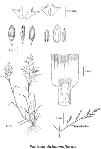


General:
Annual grass from fibrous roots, usually branching from the base; stems decumbent to erect, up to 100 cm tall/long.
Leaves:
Sheaths open, usually smooth, but the throats sometimes with a few hairs up to 3 mm long, the collars smooth; basal leaves similar to the stem leaves, the blades somewhat rough but otherwise smooth, 4-12 mm wide; ligules 2-3 mm long, the lower third membranous.
Flowers:
Inflorescence a panicle, 15-30 cm long, the branches ascending; spikelets 2-flowered, about 2.5 mm long, the lower florets sterile, the upper ones always fertile; lower glumes egg-shaped, with rounded tips, about 1/4 the length of the spikelets, 0.5-1 mm long, the upper ones smooth, lightly 9-nerved, sharp-pointed; sterile lemmas smooth, lightly 9-nerved, sharp-pointed, with translucent paleas 1-1.5 mm long; fertile lemmas much-hardened and faintly-nerved; lodicules about 0.5 mm long, semi-tubular; anthers about 1.2 mm long.

Source: The Illustrated Flora of British Columbia

Habitat / Range

Moist railway embankments and waste areas in the lowland zone; rare in SW BC (lower Fraser Valley); introduced from E and central N America.

Source: The Illustrated Flora of British Columbia

Ecology

Ecological Framework for Panicum dichotomiflorum ssp. dichotomiflorum

The table below shows the species-specific information calculated from
original data (BEC database) provided by the BC Ministry of Forests and Range.
(Updated August, 2013)

Site Information
Value / Class

Minimum

Average

Maximum

Elevation (metres) 537 537 537
Slope Gradient (%) 4 4 4
Aspect (degrees)
[0 - N; 90 - E; 180 - S; 270 - W]
167 166 167
Soil Moisture Regime (SMR)
[0 - very xeric; 4 - mesic;
8 - hydric]
5 5 5
Modal Nutrient Regime
Class
D
Number of field plots
 species was recorded in:
1
Modal BEC Zone Class
BG
All BEC Zones (# of stations/zone) species was recorded in: BG(1)

Taxonomic and Nomenclatural Links

Additional Photo Sources

General References